


Geo-Spatial Services
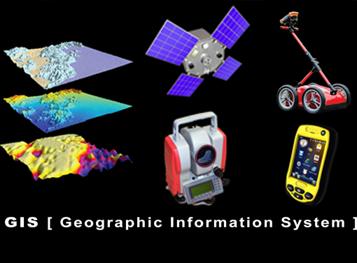
GIS is a system that collects, displays, manages and analyzes geographic information. Geographic Information Systems is a computer-based tool that analyzes, stores, manipulates and visualizes geographic information, usually in a map. The primordial functions of GIS are:
- Create geographic data
- Manage it.
- Analyze it and…
- Display it on a map.
SAAR Geospatial headquarter in Mumbai, is one of the largest GIS facilities of its kind, with a highly skilled and dedicated team of technical professionals, equipped with state-of-the-art GIS workstations , software and base-station. Our team believes in innovation in delivery by using industry best practices and stringent quality checks. We ensure our clients get value to their investments. In a world of rapidly expanding range of geospatial services SAAR Geospatial have the right products and expert knowledge to help achieve outstanding results. We specialize in GIS technologies as listed below:

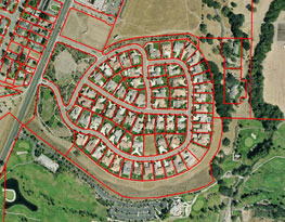
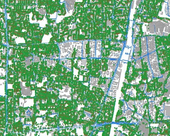
- The GIS-based property tax system covers the entire area under jurisdiction, and a unique property identification number is provided to each property.
- The property identification number is a combination of ward number, street number and plot number.
- The system provides a uniform policy to identify properties throughout its jurisdiction to levy tax.
- The system identify each and every parcel in the city/ allotted area to make correct property assessments.
- SAAR Geospatial endeavour to provide best-in-class services. We have a proven track record in Property Tax Assessment and can on-board such assignments even with higher volumes.

- Hawkers are the one who sells goods aggressively, especially by calling out. Also called crier Systematic mapping of Hawkers in urban area is an need of an hour and our GIS Hawker system does the job with ease.
- Our GIS Hawker system helps in following ways:
1.1. It allocate demarcated areas from where hawkers can trade.
2. It separates activity between hawkers and pedestrians.
3. It provides easier access to shops and entrance to buildings, railway station or other public and private properties. - SAAR Geospatial endeavour to provide best-in-class services. We have a proven track record in GIS/GPS based Hawker Mapping and can on-board such assignments even with higher volumes.
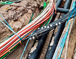
- We provide innovative utility locating and mapping, non-destructive digging and survey services.
- Using an array of geophysical, electro-magnetic and high-frequency induction techniques, we search for known and unknown utilities and structures hidden underground.
- SAAR Geospatial team has state of art technology and experience to get you best results in utility mapping.
- SAAR Geospatial endeavour to provide best-in-class services. We have a proven track record in Utility Mapping and can on-board such assignments even with higher volumes.
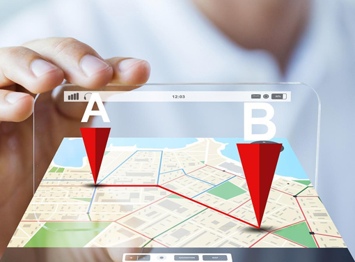
GPS, which stands for Global Positioning System, is a radio navigation system that allows land, sea, and airborne users to determine their exact location, velocity, and time 24 hours a day, in all weather conditions, anywhere in the world. GPS is used to map forests, help farmers harvest their fields, and navigate airplanes on the ground or in the air and there are many other uses, list is endless. Benefits of GPS:
- GPS provides surveying and mapping data of the highest accuracy
- Faster delivery of geographic information needed by decision makers.
- Centimetre-level surveying results in real-time.M
- Reduce maintenance costs.
SAAR Geospatial headquarter in Mumbai, is one of the largest GPS facilities of its kind, with a highly skilled and dedicated team of technical professionals, equipped with state-of-the-art workstations , software and base-station. Our team believes in innovation in delivery by using industry best practices and stringent quality checks. We ensure our clients get value to their investments. In a world of rapidly expanding range of geospatial services SAAR Geospatial have the right products and expert knowledge to help achieve outstanding results. We specialize in GPS technologies as listed below:
- Trees are vital. As the biggest plants on the planet, they give us oxygen, store carbon, stabilise the soil and give life to the world's wildlife. They also provide us with the materials for tools and shelter.
- Trees absorb carbon dioxide and potentially harmful gasses, such as sulphur dioxide, carbon monoxide, from the air and release oxygen. One large tree can supply a day's supply of oxygen for four people.
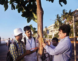
- Trees are the integral part of our flora and fauna hence it's important to have tree surveys done. And SAAR being one of the pioneers in Tree Census Surveys using GIS /GPS, brings right amount of experience and quality.
- Through intensive research SAAR has developed TREELOGY, a exclusive tree survey Application. It covers all aspects of tree survey and is considered a boon for surveyors .
- SAAR Geospatial endeavour to provide best-in-class services. We have a proven track record in GIS/GPS based Tree Census and can on-board such assignments even with higher volumes.
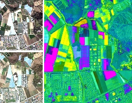
- Land cover is the physical material at the surface of the earth. Land covers include grass, asphalt, trees, bare ground, water, etc.
- Land use shows how people use the landscape – whether for development, conservation, or mixed uses.
- Our technical professionals are equipped with state-of-the-art technology and experience in Land use and Land Cover mapping.
- The system identify each and every parcel in the city/ allotted area to make correct property assessments.
- SAAR Geospatial endeavour to provide best-in-class services. We have a proven track record in Land use & Land Cover Mapping and can on-board such assignments even with higher volumes.
- Cadastral map is a map defining land ownership.
- The cadastral map consists of cadastral units, each of which represents a single registered plot of land.
- Cadastral surveying specialises in the establishment and re-establishment of real property boundaries. It is an important component of the legal creation of properties.
- SAAR Geospatial team can provide end-to-end custom solutions that meet our client's needs. We are a leading global provider for high resolution satellite imagery and provide GIS and cadastral mapping for land records, assessment, and cadastral agencies worldwide.
- SAAR Geospatial endeavour to provide best-in-class services. We have a proven track record in Cadastral Mapping and can on-board such assignments even with higher volumes.
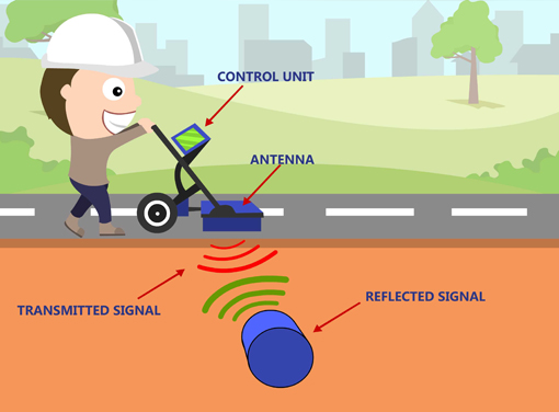
Ground Penetrating RADAR (GPR) is a geophysical method that uses radar pulses to image the subsurface. This non-destructive method uses electromagnetic radiation in the microwave band (UHF/VHF frequencies) of the radio spectrum, and detects the reflected signals from subsurface structures. Benefits of GPR:
- 1. The use of locating technologies such as GPR assist greatly in improving our understanding of what lies beneath the surface of the ground and other structure.
- 2. It also shows quantifiable benefit in improving the positional accuracy of subsurface infrastructure. Reduce maintenance costs.
- 3. Safety - GPR radar can be used to locate live electrical conduit or other hazardous utility lines prior to cutting, digging, or construction.
SAAR Geospatial headquarter in Mumbai, is one of the largest GPR facilities of its kind, with a highly skilled and dedicated team of technical professionals, equipped with state-of-the-art technologies, software and base-station. Our team believes in innovation in delivery by using industry best practices and stringent quality checks. We ensure our clients get value to their investments.In a world of rapidly expanding range of geospatial services SAAR Geospatial have the right products and expert knowledge to help achieve outstanding results. We specialize in GPR technologies as listed below:
- Using an array of geophysical, electro-magnetic and high-frequency induction techniques, we search for known and unknown utilities and structures hidden underground.
- A utility map shows the positioning and identification of buried pipes and cables beneath the ground. The procedure involves detecting things like sewers, electric cables, telecoms cables, gas and water mains. Combine this mapping process with a topographical survey and the results will provide you with a comprehensive detailed map of anything that is hidden underground or directly related to any above ground features.
- SAAR Geospatial team has state of art technology and experience to get you best results in utility mapping.
- SAAR Geospatial endeavour to provide best-in-class services. We have a proven track record in Utility Mapping and can on-board such assignments even with higher volumes.
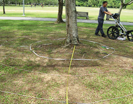
- The GPR system can determine the length of individual roots, from stem to the smallest detectable width.
- GPR uses electromagnetic radiation in the microwave band (UHF/VHF frequencies) of the radio spectrum, and detects the reflected signals from subsurface structures.
- And Applying higher frequencies together with smaller measurement intervals can leads to a accuracy of tree roots to less then 1 cm.
- SAAR Geospatial endeavour to provide best-in-class services. We have a proven track record in Tree-Root Mapping and can on-board such assignments even with higher volumes.
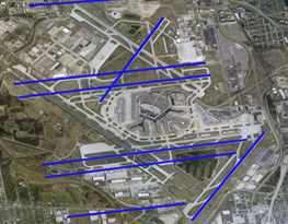
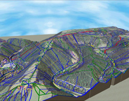
- Road Mapping helps to transform transportation planning.
- This helps to plan, monitor, and manage infrastructure more effectively.
- SAAR Geospatial team has state of art technology and experience to get you best results in utility mapping.
- SAAR Geospatial team can provide end-to-end custom solutions that meet our client's needs. We are a leading global provider for high resolution satellite imagery and provide GIS and cadastral mapping for land records, assessment, and cadastral agencies worldwide.
- SAAR Geospatial endeavour to provide best-in-class services. We have a proven track record in Roads Mapping and can on-board such assignments even with higher volumes.
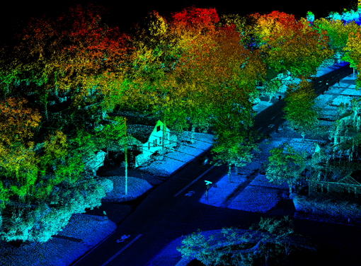
LiDAR (Light Detection And Ranging) is a remote sensing method used to examine the surface of the Earth. LiDAR uses light in the form of a pulsed laser to measure ranges (variable distances) to the Earth. These light pulses combined with other data recorded by the airborne system and generate precise, three-dimensional information about the shape of the Earth and its surface characteristics. Benefits of LiDAR :
- 1. Data can be collected quickly with very high accuracy.
- 2. Collect elevation data in a dense forest, where photogrammetry fails to reveal the accurate terrain surface due to dense canopy cover.
- 3. Lidar does not have any geometric distortions like a side-looking radar.
- 4. Lidar can be integrated with other data sources.
SAAR Geospatial headquarter in Mumbai, is one of the largest LiDAR facilities of its kind, with a highly skilled and dedicated team of technical professionals, equipped with state-of-the-art technologies, software and base-station. Our team believes in innovation in delivery by using industry best practices and stringent quality checks. We ensure our clients get value to their investments. In a world of rapidly expanding range of geospatial services SAAR Geospatial have the right products and expert knowledge to help achieve outstanding results. We specialize in LiDAR technologies as listed below:
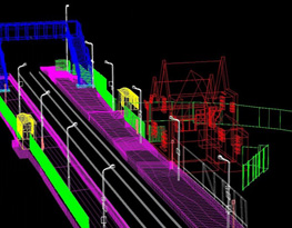
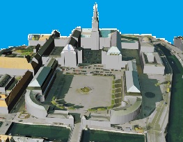
- Through Airborne LiDAR System, data is collected by a high-speed data recorder
- The 2D buildings footprints are detected and extracted either from LiDAR data or the combination of LiDAR and orthophotos data.
- Then Using photogrammetry, a 3D city model is produced from stereo aerial imagery in a semi-automatic way using special software tools.
The main advantages are :
1. High point density
2. High spatial resolution
3. Accuracy of acquired data sets - SAAR Geospatial team has state of art technology and experience to get you best results in 3D Modeling.
- SAAR Geospatial endeavour to provide best-in-class services. We have a proven track record in 3D Modeling and can on-board such assignments even with higher volumes.
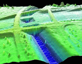
- A Digital Elevation Model (DEM) is a digital model or 3D representation of a terrain's surface created from terrain elevation data.
- SAAR Geospatial team has state of art technology and experience to get you best results in Terrain Modelling.
- Advantages of using DEM:
1. Accuracy and Quality
2. Extensive Geographic Coverage
3. Quick Turn-around Times - SAAR Geospatial endeavour to provide best-in-class services. We have a proven track record in Terrain Modelling and can on-board such assignments even with higher volumes.
- Topography is a study of structure and features of the material surface. It ranges in macro, micro and nanometers. Topography covers the three-dimensional structure of the surface, and the identification of specific profile.
- Advantages of using Topography:
1. It provides necessary data of LAND before making any changes.
2. Data regarding changes made to the land prior to being used can be produced.
3. Complete and accurate image of land and the surrounding area can be produced. - SAAR Geospatial team has state of art technology and experience to get you best results in Topography Surveys.
- SAAR Geospatial endeavour to provide best-in-class services. We have a proven track record in Topography Surveys and can on-board such assignments even with higher volumes.
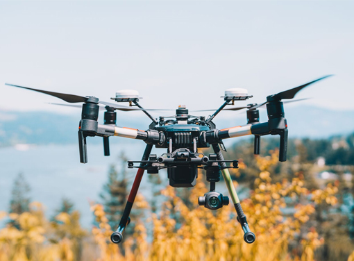
A drone, in a technological context, is an unmanned aircraft. Drones are more formally known as unmanned aerial vehicles (UAVs) or unmanned aircraft systems (UASes). Drones are now also used in a wide range of civilian roles ranging from search and rescue, surveillance, traffic monitoring, weather monitoring and fire-fighting to personal drones and business drone based photography, as well as videography, agriculture and even delivery services.
- Benefits of Drone Survey:
1. Better overview.
2. Survey of inaccessible locations.
3. Faster data acquisition & Higher data resolution with Low cost. It also reduces time spent.
SAAR Geospatial headquarter in Mumbai, is one of the largest Drone Survey facilities of its kind, with a highly skilled and dedicated team of technical professionals, equipped with state-of-the-art technologies, software and base-station. Our team believes in innovation in delivery by using industry best practices and stringent quality checks. We ensure our clients get value to their investments. In a world of rapidly expanding range of geospatial services SAAR Geospatial have the right products and expert knowledge to help achieve outstanding results. We specialize in Drone Survey technologies as listed below:
- Possibilities around how drones can be used are limitless.
- SAAR Geospatial team has state of art technology and experience to get you best results in Drone Survey (Change Detection).
- This ability to quickly review the changes on a jobsite is called “Change Detection.” And with Change detection it is easier to determine progress of jobsite with a single glance.
- SAAR Geospatial endeavour to provide best-in-class services. We have a proven track record in 3D Modeling and can on-board such assignments even with higher volumes.
Topography is a study of structure and features of the material surface. It ranges in macro, micro and nanometers. Topography covers the three-dimensional structure of the surface, and the identification of specific profile.
- Advantages of using Topography:
1. It provides necessary data of LAND before making any changes.
2. Data regarding changes made to the land prior to being used can be produced.
3. Complete and accurate image of land and the surrounding area can be produced. - SAAR Geospatial team has state of art technology and experience to get you best results in Topography Surveys.
- SAAR Geospatial endeavour to provide best-in-class services. We have a proven track record in Topography Surveys and can on-board such assignments even with higher volumes.
- An orthophoto is an aerial photograph or image geometrically corrected ("orthorectified") such that the scale is uniform, the photo has the same lack of distortion as a map.
- An orthophoto mosaic is a raster image made by merging orthophotos. And the document (digital or paper) representing an orthophoto mosaic with additional marginal information like a title, north arrow, scale bar and cartographical information is called an orthophoto map or image map.
- Advantages of Orthophoto Generation:
1. It provides a precise method in constructing a GIS database.
2. It is a more cost-effective mapping tool compared to conventional line mapping.
3. The speed of the technique is amazingly high, making the map production quick. - SAAR Geospatial team has state of art technology and experience to get you best results in Topography Surveys.
- SAAR Geospatial endeavour to provide best-in-class services. We have a proven track record in Topography Surveys and can on-board such assignments even with higher volumes.
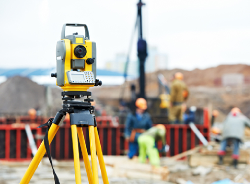
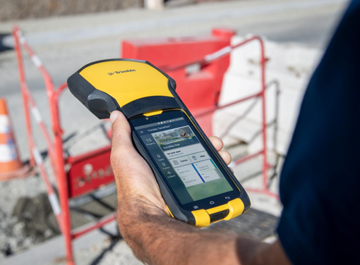
The total station is an electronic theodolite (transit) integrated with an electronic distance measurement (EDM) to read slope distances from the instrument to a particular point, and an on-board computer to collect data and perform advanced coordinate based calculations. Total Stations use electronic transit theodolites in conjunction with a distance meter to read any slope distance from the instrument to any particular spot. Benefits of Total Station:
- 1. Improved accuracy.
2. Can be operated at a distance, hence requiring only one surveyor in the field, rather than the traditional two.
3. Total Stations include up-to-date image capture technology, which can record any image or screen-view from the surveying site, eliminating the need for costly revisits, and producing high-resolution images of site conditions.
4. The data processed and stored in the Total Station can be downloaded to other computer systems, for archiving or distribution, or to be used with other applications such as mapping software.
SAAR Geospatial headquarter in Mumbai, is one of the largest Total Station Survey facilities of its kind, with a highly skilled and dedicated team of technical professionals, equipped with state-of-the-art technologies, software and base-station. Our team believes in innovation in delivery by using industry best practices and stringent quality checks. We ensure our clients get value to their investments. In a world of rapidly expanding range of geospatial services SAAR Geospatial have the right products and expert knowledge to help achieve outstanding results. We specialize in Total Station Survey technologies as listed below:
- SAAR being one of the pioneers in Tree Census Surveys, brings right amount of experience and quality.
- SAAR Geospatial team has state of art technology and experience to get you best results in Tree Mapping.
- Through intensive research SAAR has developed TREELOGY, a exclusive tree survey Application. It covers all aspects of tree survey and is considered a boon for surveyors .
- SAAR Geospatial endeavour to provide best-in-class services. We have a proven track record in Tree Mapping and can on-board such assignments even with higher volumes.
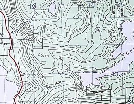
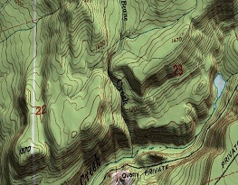
Contour mapping, the delineation of any property in map form by constructing lines of equal values of that property from available data points.
- A contour maps consists of contour lines which are imaginary lines connecting points of equal elevation. Such lines are drawn on the plan
of an area after establishing reduced levels of several points in the area.
From the contours, it is possible to determine the capacity of a reservoir.
SAAR Geospatial team has state of art technology and experience to get you best results in Topography Surveys.
SAAR Geospatial endeavour to provide best-in-class services. We have a proven track record in Topography Surveys and can on-board such assignments even with higher volumes.
Mobile GIS is taking Geographic Information Systems (GIS) out of the office and into the field. In the field Mobile GIS allows to capture, store, update, manipulate, analyze, and display geospatial data and information. Mobile GIS integrates mobile devices (such as a Mobile Phones, PDA, tablet, or laptop computer) with Geographic Information System (GIS) software , Global Positioning System (GPS) and wireless communications for Internet-based GIS access.
In the era of continuous technology inventions, Mobile GIS helps seamlessly in all kind of Field survey work Our team believes in innovation in delivery by using industry best practices and stringent quality checks. We ensure our clients get value to their investments. In a world of rapidly expanding range of geospatial services SAAR Geospatial have the right products and expert knowledge to help achieve outstanding results. Few Mobile GIS application developed by SAAR Geospatial:
Mobile GIS
Treelogy (Tree Survey App)
Propmate (Property Survey App)
Postmate (Product Delivery Tracking App)
Web GIS is a type of distributed information system, comprising at least a server and a client, where the server is a GIS server and the client is a web browser, desktop application, or mobile application. Web GIS advantages:
- 1. Reduce lead times
- 2. Improve cross-collaboration
- 3. Connect multiple structured data source
- 4. Support real-time spatial analysis
- 5. Access web-maps from any device remotely
Our team believes in innovation in delivery by using industry best practices and stringent quality checks. We ensure our clients get value to their investments. In a world of rapidly expanding range of geospatial services SAAR Geospatial have the right products and expert knowledge to help achieve outstanding results.