LiDAR
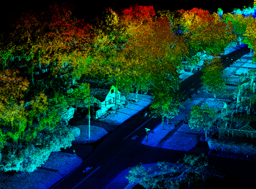
LiDAR (Light Detection And Ranging) is a remote sensing method used to examine the surface of the Earth. LiDAR uses light in the form of a pulsed laser to measure ranges (variable distances) to the Earth. These light pulses combined with other data recorded by the airborne system and generate precise, three-dimensional information about the shape of the Earth and its surface characteristics. Benefits of LiDAR :
1. Data can be collected quickly with very high accuracy.
2. Collect elevation data in a dense forest, where photogrammetry fails to reveal the accurate terrain surface due to dense canopy cover.
3. Lidar does not have any geometric distortions like a side-looking radar.
4. Lidar can be integrated with other data sources.
SAAR Geospatial headquarter in Mumbai, is one of the largest LiDAR facilities of its kind, with a highly skilled and dedicated team of technical professionals, equipped with state-of-the-art technologies, software and base-station. Our team believes in innovation in delivery by using industry best practices and stringent quality checks. We ensure our clients get value to their investments. In a world of rapidly expanding range of geospatial services SAAR Geospatial have the right products and expert knowledge to help achieve outstanding results. We specialize in LiDAR technologies as listed below: